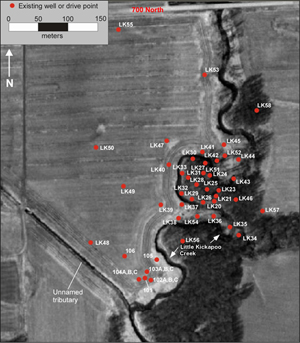
Well Field
The well field is located on the banks Little Kickapoo Creek on property owned by the Bloomington-Normal Water Reclamation District (BNWRD). It is used for teaching field methods in classes at the undergraduate and graduate level. It is also being used as the site of undergraduate and graduate research projects. We are continually expanding the instrumentation and uses of the well field.
Geologic Setting
The well field sits in a valley eroded by glacial meltwater during the Pleistocene, and the valley is occupied by the modern Little Kickapoo Creek. The aquifer in which the wells are installed is composed of coarse-grained (gravel and sand) outwash deposited by meltwater (the Henry Formation).
Both the erosion of the valley and partial backfilling occurred when the ice front was stationary several km north of the site. The aquifer is 5-7 meters thick in the center of the valley and pinches out at the edges of the valley. The base of the aquifer, at depth of 8-10 meters below the surface, is defined by the low permeability till of the Wedron Formation. The Wedron sediments are clay-rich lodgement tills deposited by continental glaciers during the Wisconsinan period of the Pleistocene. The aquifer is overlain by 2-3 of fine-grained Holocene floodplain sediments of the Cahokia Formation. Little Kickapoo Creek is inset into the Cahokia and rests on top of the Henry.
Activities
Teaching
The well field is used for field exercises for numerous undergraduate and graduate classes. Regular activities that are conducted as a part of classes include hydraulic head measurements (manual and continuous), field water quality measurements, water sampling, field chemical analyses, aquifer tests, slug tests, vadose zone tests, injected tracer tests, stream flow measurements, and collection of precipitation data.
Research
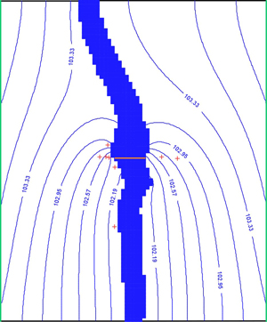
Research projects are focused on groundwater and surface water interactions. Current research projects include using temperature variations to model hyporheic flow in the stream bed, using numerical modeling to quantify nitrogen cycling between the stream and aquifer, quantifying the effects beaver dams on nitrogen and phosphorus cycling, and using numerical models to quantify seepage and nitrogen removal from a constructed wetlands receiving treated waste water effluent.