Reservoir Modeling
Research Info
Student: John Wagle
Advisors: Dave Malone
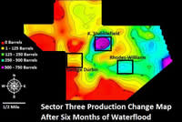
The purpose of this research was to analyze geologic, geophysical, and hydrologic properties at the Loudon oil field in south central Illinois in order to ascertain what conditions contributed to the success or failure of a waterflood operation in Mississippian aged reservoir units. This research focused on three-dimensional subsurface modeling of porosity, facies, and structure in order to establish a sense of the continuity between producers and injectors. There is also an emphasis on fluid characteristics in this work, another factor which greatly impacted the success or failure of waterflood at Loudon. The Loudon field is located in Fayette County, Illinois. Widespread waterflooding began in 2007 and continues today. Petco Petroleum Corporation began waterflooding Sector Three in 2008 with mixed results. The research delineated three cases in Sector Three which experienced different levels of success, in order to better understand the controls upon waterflooding at this field.
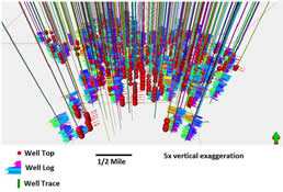
The three-dimensional porosity modeling was accomplished in Petrel, an industry leading software suite designed to characterize petroleum reservoirs. The Petrel models shed light on the reservoir geometry and porosity conditions in Sector Three. These models illustrated the relationship between porosity, structure, and overall enhancement of petroleum production. The facies modeling was accomplished by manual interpretation of facies based on porosity and gamma ray well logs. These data were collected from the ISGS ILOIL program, a data clearinghouse for petroleum well logs and other pertinent information. By clarifying the lithologies throughout the lease, the relationship between facies and porosity becomes clear and allows a more in depth examination of the relationship between the injector, producer, and lease geologic conditions.
Recent related publications include:
- Wagle, J.*, Malone, D. H., Peterson, E. W., and Tranel, L., 2016, Porosity controls on secondary recovery at the Loudon Field, south-central Illinois: Interpretation, v. 4, no. 1, doi:10.1190/INT-2015-0078.1.
- Kron, N.*, Malone, D. H., and Peterson, E. W., 2015, Three-Dimensional Geologic Model of the Pecatonica Gas Storage Field, Winnebago County, Illinois: World Journal of Environmental Engineering, v. 3, no. 4, p. 121-125.
- Kimple, D.*, Peterson, E.W., and Malone, D.H., 2015, Stratigraphy and porosity modeling of southern central Illinois Chester (Upper Mississippian) series sandstones: World Journal of Environmental Engineering, v. 3, no. 3, p. 82-86, doi: 10.12691/wjee-3-3-2.
- Peterson, E.W., Martin, L. I.*, and Malone, D. H., 2015, Identification of Potential Vertical Gas Migration Pathways above Gas Storage Reservoirs: World Journal of Environmental Engineering, v. 3, no. 2, p. 23-31, doi: 10.12691/wjee-3-2-1